Kamay Bay National Park

Kamay Bay National Park is situated in Kurnell, about 50 minutes south of Sydney.

Barrawang walk, starting at the main car park / visitor’s centre, takes you down to Captain Cook’s landing spot and also an interesting sculpture on the water’s edge. It’s an easy 1.2km loop and a large part of it is wheelchair accessible. There is are also a grassed picnic area with tables.

Kape Solander is a great viewing spot for whales. You can either drive there or get there via a 40 minute (one way) walk from the visitor centre. The walk through the bush isn’t all that interesting, so I’d suggest driving instead. Keep in mind during whale watching season (mid June – mid July and September – mid November) it can get very busy on the weekends. Try to get there early to avoid traffic delays and the possibility the park may be closed to further visitors.

Overall verdict, decent spot for a picnic, whale watching and some history but if you are after a good bushwalk, there are better options.

https://www.nationalparks.nsw.gov.au/visit-a-park/parks/kurnell-area

Kuringai Chase National Park Basin and Mackerel Tracks

The Basin and Mackerel Tracks are two of the many great walks in the Kuringai Chase National Park which is about 45 minutes north of the city. You can do either track individually, but a better way is to do both to loop back to your starting point, a walk of about 6 kms. Allow 2 1/2 – 3 hours to complete the loop, including a short ferry ride.

The Mackeral track is quite rough in places, so it’s a good idea to wear hiking boots or some other sturdy shoes.

Start with the Basin Track. In the park turn right onto West Head Road at the junction with Liberator General San Martin Drive Junction. From there drive about 8.5kms. The entrance to the track will be on the right hand side. There is a small car park right near the entrance.

Not far after you enter the track there is an Aboriginal Art site which is worth a quick stop.

The trail winds down toward the Basin campground. Along the way you’ll see glimpses of the bay. There are lots of native wildflowers along the edge of the path. We also saw a goanna soaking up the sun by the side of the trail.

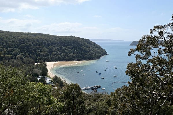
At the campground there are public toilets and picnic tables as well as great views across the bay. There is a small shop however it only sells ice and bait. There is also a vending machine near the bathrooms if you want to pick up a snack.

The campground is also home to some wallabies and kookaburras, who are very used to people and happy to pose for photos.

To continue onto the Mackerel track you’ll need to catch the Palm Beach ferry from the campground wharf. The ferry runs every hour from 9am until early evening. There is a timetable posted in the shed at the entrance t the wharf. The ferry ride to Mackerel beach takes about 10 minutes.

When you get off the ferry turn left. You’ll see lots of wheelbarrows which the locals use to cart their groceries as the properties are only accessible via water. Continue along the path with the water on your left. Continue straight past the path which heads off to the right.

Around 50 metres further along you’ll see a path winding up toward the houses. Take this path. From here it isn’t well sign posted. At one point you have to walk through one of the properties (there is a sign at the entrance which says private property enter at your own risk). At the next property you’ll see an arrow, follow it.

Once you get past the properties the path winds up the hill and into the bush. The terrain is pretty rough and in places the path is not all that obvious. Keep an eye out for the red reflectors which are posted every now and again to mark the trail.

The climb is worth it for the great views back across Pittwater from the top of the hill.

From here the track levels out more and eventually joins up with the Basin Track shortly before the Aboriginal site to return you to the starting point.

https://www.nationalparks.nsw.gov.au/things-to-do/walking-tracks/the-basin-track-and-mackerel-track

Lane Cove National Park Riverside Circuit Walk

Lane Cove National Park is situated around 20 minutes drive from the city. It’s a great place to go for a picnic or a short walk but I’d recommend walking one of the longer trails.

The park is accessible via car (with onsite parking $8 for a day) or public transport via either North Ryde (walking distance) or Chatswood train stations (via a bus from the station).

The Riverside Circuit Walk is around 11 kms and takes about 3 hours so is doable in a morning or afternoon trip.

The walk consists of 2 different walks – the Riverside Walking Track and the Lane Cove Valley Walk which forms a circuit around the river. The Valley Walk forms part of the 250km (one way) Great Northern Walk that links Sydney and Newcastle.

You can start either side of the circuit just near the Lane Cover park entrance on Riverside Drive. The Riverside Walking Track along the western bank of the river is a relatively easy walk. The Valley Walk along the east side of the river is more challenging. Whichever is best to start with depends on if you want to ease yourself into the walk or if you’d rather start off harder and finish easy.

Even on the Valley Walk you can get away without hiking boots, but make sure you where trainers or some other sturdy shoes.

The scenery along the way is quite varied, with lots of different trees and plants. You’re also likely to be serenaded by kookaburras and cockatoos during the walk. There are some bathroom facilities along the way but it’s advisable to bring enough water for the walk or buy some at the cafe near the entrance to the Park.

Information about the walk, facilities and how to get to the park is included no the National Parks website:

https://www.nationalparks.nsw.gov.au/things-to-do/walking-tracks/riverside-walking-track/visitor-info#Getting-there-and-parking

Proudly powered by WordPress | Theme: Baskerville 2 by Anders Noren.

Up ↑